
Smartphone Apps for Aid Workers: Staying Safe, Informed and Connected |
|
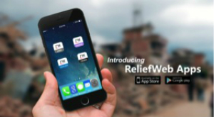
Wednesday, 6 December 2017 Smartphones. They are ubiquitous in today’s world, with the number of global smartphone users predicted to reach 2.87 billion by 2020. We use them for traditional phone activities, such as calls and texting, but also to help us shop, read a book, or settle an argument with a quick Google search. In 2014, nearly half of Americans (46%) said their smartphone was something “they couldn’t live without”, according to the Pew Research Center, and in 2015, median smartphone adoption in developing nations hit 37%. They’re especially vital for aid and humanitarian workers. In recent years, as mobile network accessibility has improved around the world, innovative applications have been developed to address humanitarian needs and solve development challenges. Aid workers now have real-time access to critical data and information during an emergency, safety and security updates, travel health advice, global news, technical guidelines, job postings and foreign language resources. Following is a list of some of the most useful humanitarian smartphone apps. All are free to download, unless otherwise noted, and most have options for offline access. ReliefWeb app series - A well-known internet hub for humanitarian workers, ReliefWeb provides a series of apps that mirror the various sections of their website. All the apps allow you to bookmark content to return to later, and to share content across social media platforms.
Médecins Sans Frontières (MSF) app series - Médecins Sans Frontières/Doctors Without Borders has released several apps that detail their work, conduct crowdmapping efforts and, most recently, make their medical guidelines available at the touch of a button.
CrisisSignal - Collects real-time data on cellular and WiFi coverage during and after emergency situations. Designed to be used on devices located in the disaster-affected zones, the data collected from every user is aggregated to build a real-time map of coverage. Umbrella: Security made easy - Currently in beta testing, this app is designed by and for people travelling in high-risk areas, such as journalists, aid workers, human rights defenders and activists. Provides lessons, step-by-step advice, and checklists needed to operate safely in a hostile environment, from how to send a secure email, to attending a protest, or dealing with a kidnapping. Also provides up-to-date security information from the UN, ReliefWeb, and the CDC with the latest threats in specific local areas.
Disaster Alert - An interactive map showing active hazards as they occur around the world. Includes hurricanes & cyclones, earthquakes, floods, tsunamis, volcanic activity, marine disasters, storms, and manmade disasters. Information on wildfires to be added soon. Epidemic Tracker - Allows users to follow reports of major infectious disease outbreaks provided by government and humanitarian reports in the past 72 hours. Filters outdated material and low-threat outbreaks. Currently tracking: cholera, dengue, ebola, polio, malaria, measles, MERS-CoV and Zika.
Humanitarian Kiosk - Provides a range of current humanitarian information from emergencies around the world. Select the ‘kiosks’ you are interested in, and they will automatically download and sync to your mobile device for offline browsing at a later time. HSPapp (Humanitarian Standards Partnership) - Provides access to the Humanitarian Charter, Protection Principles, Core Humanitarian Standard and standards for the following key areas of humanitarian response: WASH, shelter and non-food items, food security and nutrition, health action, child protection, education, livestock management, market analysis, and economic recovery. Primarily in English, with some content in French and Spanish. GDACS - Provides real-time access to web-based disaster information systems and related coordination tools, including alerts and impact estimations, standards and guidelines for international information exchange, access to the coordination platform “VirtualOSOCC” for disaster managers, disaster maps and satellite images, and detailed weather forecasts.
Relief Central - An information hub for relief workers and first responders that includes the latest versions of several important resources, including the CIA World Factbook, CDC Travel Health Information (CDC Yellow Book), Ebola Guidelines, the USAID Field Operations Guide, an RSS feed called Relief News, and MEDLINE Journals citations and abstracts. OPI Translate - A free mobile translation app combined with access to optional, live over-the-phone interpretation (OPI) services at a competitive cost. The free component can translate between 60+ foreign languages, allows the user to translate text captured with a phone camera, voice-to-voice communications, audio output of text translations, has SMS, email and social media integration, and allows for creation of customized phrasebooks. The optional paid interpreter service is available in over 150 languages, provides one button access to live, professional interpreters with cultural and linguistic proficiencies in both languages, and is competitively priced based on per minute usage, with no set minimum, no set-up charge, no monthly fees, and no contract. Global SOS: Emergency Numbers - Automatically provides a map, location address, GPS coordinates, and identifies emergency services phone numbers (such as police, fire, medical) for whichever country the device is currently located in. Covers more than 240 countries worldwide, and can work without internet or a SIM card.
Sources:Number of smartphone users worldwide 2014-2020, accessed 28 November 2017, https://www.statista.com/statistics/330695/number-of-smartphone-users-worldwide/ 10 facts about smartphones, 28 June 2017, http://www.pewresearch.org/fact-tank/2017/06/28/10-facts-about-smartphones/ Missing Maps project, accessed 29 November 2017, https://www.msf.org.uk/missing-maps-project Photo courtesy of Pixabay |

 Voxer -
 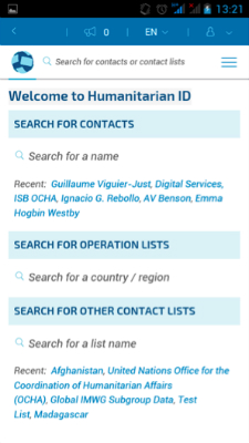 Humanitarian ID -
  Natural Disaster Monitor -
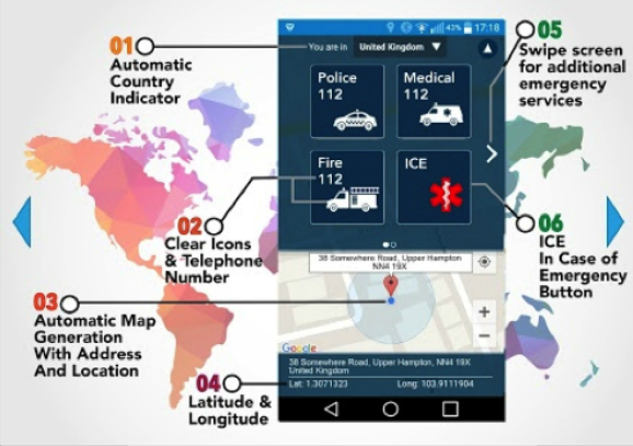
Contact Us